HiLandEr - Hidden water and landscape erosion
 NEWS
NEWS
PRODUCTS BECOMING VISIBLE (March 2025). The concept is set and during the first year, more and more products and preliminary results emerge from the joint project scopes. See details
WE HAVE SEEN FLOODS AND SNOW (January 2025). The joint winter field trip yielded fabulous insights to what a fully saturated landscape looks like and how it triggers bankfull discharge across the drainage network. Perfect conditions for reference data collection throughout! See details
WE HAVE FIRST INSIGHTS (October 2024). The first HiLandEr poster has seen the light of a conference (DGGM 2024 Meeting) and kickstarted ample discussions on approaches, field sites and the longer vision of the project.
WE ARE COLLECTING DATA (June 2024). Together with the PhD students, we had spend a week in the study area, the Ahr Valley and its contributaries. We were able to install river gauges and suspension load sensors, sample numerous springs and set up ten seismic stations. Hence, we are ready for the data to trickle in and the first lab results to emerge.
WE ARE DISEMBARKING (May 2024). We have assembled the full project team! We were able to attract two excellent PhD students: Laura Fracica for the seismic and Benoit Abadie for the modelling focus. Welcome on board.
WE ARE BUILDING THE TEAM (Jan 2024). Currently, we are in the process of recruiting the two PhD students from the pool of submitted applications. For efficient project enrollment, we will be out in the field for scouting, expecting crisp weather and a shiny landscape.
WE ARE HIRING (Nov 2023). We are seeking early stage researchers to take on one of two PhD positions in the HiLandEr project. The position at IFPEN, France, will focus on numerical model development (details and call see here). The position at Uni Göttingen, Germany, will focus on instrumental field data collection and analyses (call, application form).
SCOPECatastrophic floods and sustained droughts will be increasing as our climate changes. It is uncertain how this change will impact the watersheds of major rivers during hydrological extremes. A crucial element in the routing of discharge, and its erosive impact on landscapes, is subsurface storage of water and its pathways within the critical zone. The challenge is in both observing and predicting change in subsurface water amounts and fluxes.
In HiLandEr, we explore this important hidden water compartment from two complementary sides: by spatially distributed measuring (overcoming limitations of current point-like measurements) and by landscape wide modelling (overcoming current model oversimplifications). We will jointly survey groundwater and fluvial dynamics using passive seismology and water chemistry to build a picture of the subsurface flow paths and quantities. We will in parallel develop the methods to efficiently numerically model both the hydrology and sediment yield of the system. This research project will help improve flood anticipation, give insight into hydraulic breakpoints (initiation of overland flow and erosion), and understand future response in the critical zone due to climate change.
TEAM
Laura Rossana Fracica Gonzalez
SCIENTIFIC BACKGROUND: Born and raised in Bogotá, Colombia, I've always had a deep love for nature. This passion led me to earn my bachelor’s degree in Geology from Universidad Nacional de Colombia and undertake a research internship at Purdue University, focusing on geochemical modeling of glaciated mountain aquifers. Later, I completed my master’s degree at Northern Illinois University, where I developed a method to use ADCP technology to measure groundwater flow in the cenotes (sinkholes) of Mexico's Yucatán Peninsula. VISION OF THE PROJECT: Currently, I'm excited to be part of the HiLandEr project at Göttingen University, focusing on the seismic front. My role involves uncovering the hidden dynamics of groundwater using distributed seismic surveys, particularly examining the critical zone pathway and its impact on the landscape's response to hydrological extremes like flooding. |
Benoit Abadie
SCIENTIFIC BACKGROUND: After my undergraduate degree in marine sciences, I decided to study the water cycle on a broader spectrum by completing a master's degree in 'Water sciences' at the Université de Pau et des Pays de l'Adour (UPPA), France. My masters studies, having focused primarily natural waterways, gave me a solid background for my curent PhD research in the context of the HiLandEr project. My PhD research is primarily focused on simply and accurately modelling the flow of water on a catchment surface and subsurface as well as in between. VISION OF THE PROJECT: My hopes are that the knowledge gained from the HiLandEr project will allow a better understanding of the complex interactions and pathways by which water flows through a catchment. This will facilitate the prediction of catastrophic events thus helping with future planning and development projects in a changing climate. |
HiLandEr is a joint ANR-DFG funded research project that brings together four research institutes in France (IFP Energies Nouvelles Paris & Université de Rennes) and Germany (Georg-August University Göttingen & GFZ Potsdam). With HiLandEr, there will be two PhD projects, enrolled at IFPEN and Uni Göttingen. The IFPEN project, pushed by Benoit Abadie, focusses on the development of a numeric landscape evolution model that can describe the interaction between the surface and the subsurface and is capable of predicting the risk of future catastrophic floods on a 10-to-100-year timescale (scope see here). The Göttingen project, pushed by Laura Fracica, follows an empirical approach, by installing a network of seismic and hydrological stations to constrain both surface fluxes and groundwater dynamics (background see here). The project bridges scientific fields, including hydrology, hydrogeology, geomorphology, geochemistry, and sedimentology in order to understand how the subsurface impacts erosion and sediment yield.
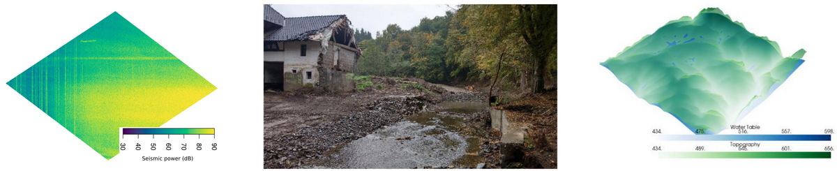
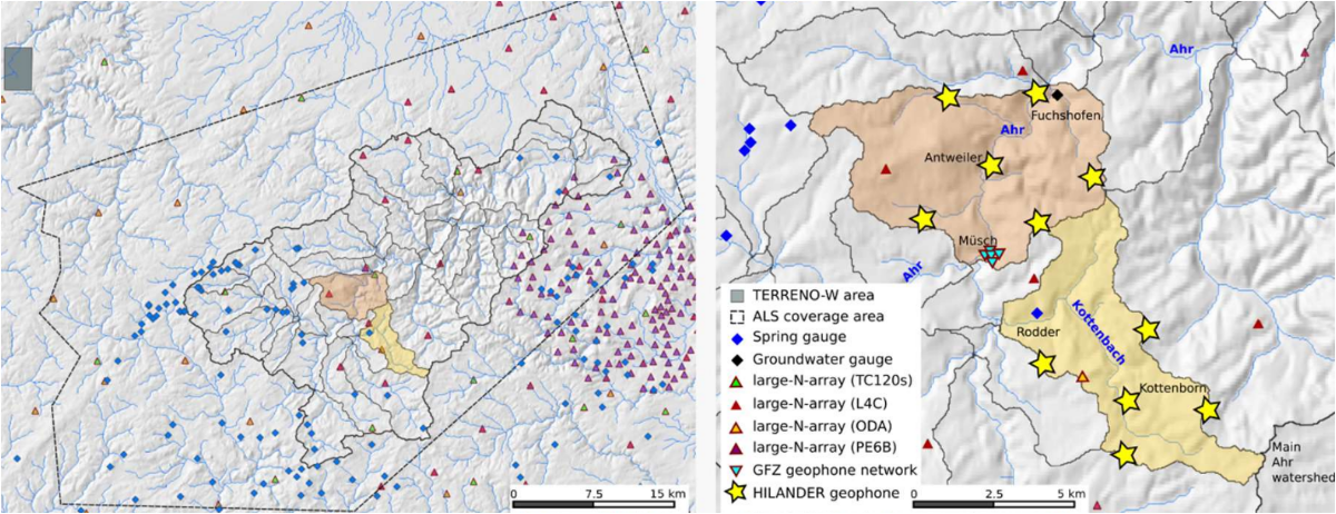
APPROACHBoth projects are set up in nested upland catchments of the Eifel region, Germany. That area, characteristic for many European landscapes, had experienced a catastrophic flood event in summer 2021 (details see here). Through rapid response actions, there are very high-resolution ground data available. In addition, a GFZ-coordinated large-N-array experiment contributes six months of data from 350 seismometers, spread across the Eifel. That pool of information (Fig. below, left), in combination with additional instruments set up during the project phase (Fig. below, right) and the transfer of those data into a numerical model approach, allows to i) observe water and sediment discharge and its modulation by critical zone dynamics, ii) characterisating the relationship between subsurface saturation and erosion events, and iii) constraining water pathways and causes of non-linear system behaviour.
 WINTER CONDITIONS
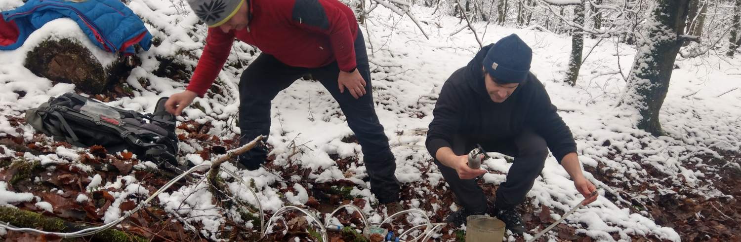
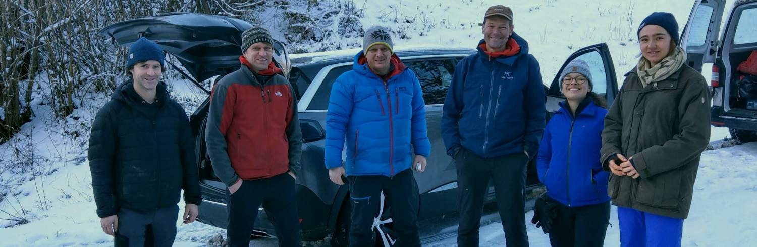
In January 2025 we set out as a team to collect key samples, to scout springs only active in winter time, collect data sets from loggers that have been gathered in the past months, and to understand how the landscape under study operates under saturated conditions. And saturated was that landscape indeed. See the Ahr near the town of Müsch under bankfull discharge conditions while the valley slopes are still snow covered.
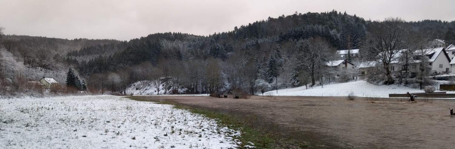
Not only the Ahr as main river was at full capacity, also the tributaries – the instrumented Huhnenbach and Michelsbach – were carrying proper amounts of water, more that we could have wished for with respect to the plan to change sensors under water...
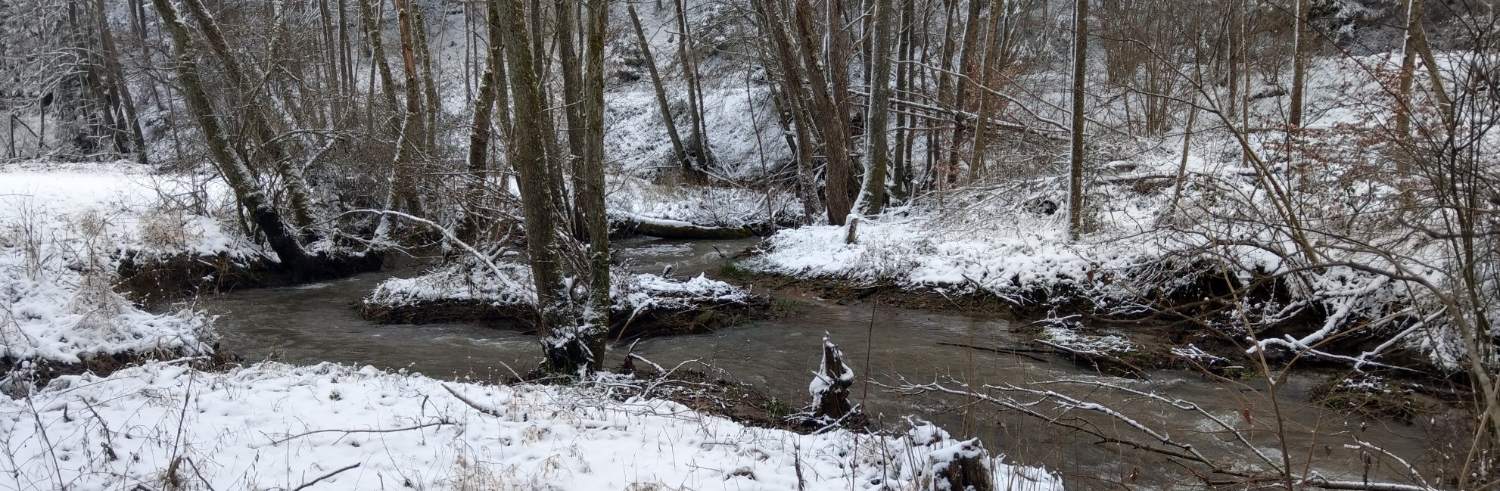
Scouting and mapping springs as source points for surface water was deliberately easy due to the fresh fallen snow and just the right temperatures that allowed spring waters to melt it.
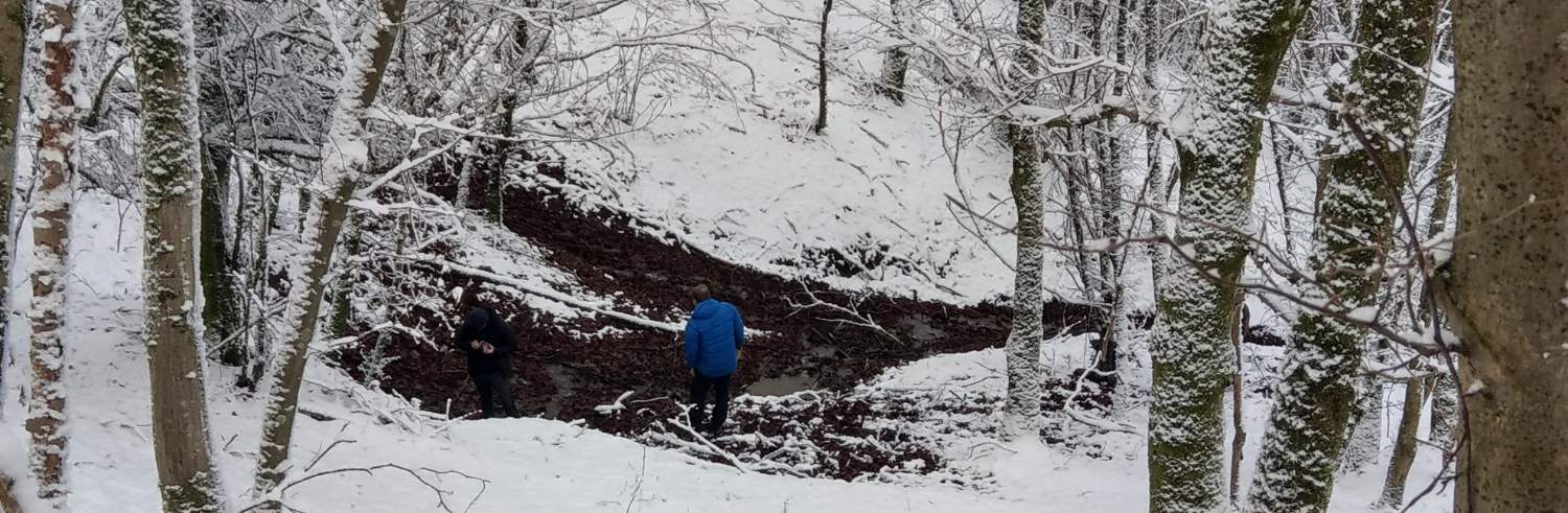
Sampling those springs for chemistry was less delightful, especially when discharge was poor and holding slowly filling water bottles and sample tubes still for many minutes. Well done, Benoit!
In the end, the team was (still) happy, looking forward to what the data will show and especially having had a unique chance to see a landscape at its end-member stage of water budget management.
 SOME UPCOMING OUTPUT
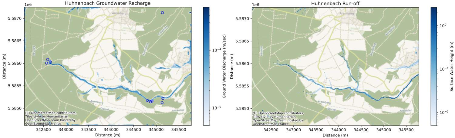
The groundwater table model is taking shape. Groundwater flux is estimated to be dominated by lateral flow. The displayed steady state example from one of the studied catchments results from a 600 mm/a precipitation scenario.
Wherever the groundwater table intersects with topography, the model will enforce surface runoff, first as distributed flow, then as channelised flow. The model predictions will be compared against field evidence, especially to tile drainage infrastructure, preventing surface runoff in favour of pipe-based channelised discharge out of headwater catchments.
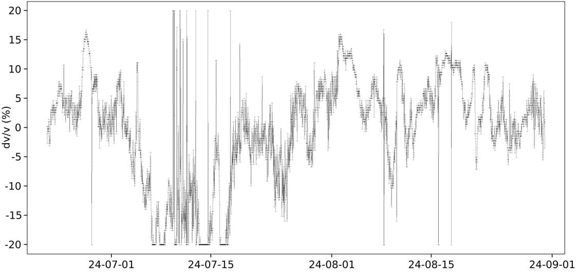
The next important step will be, in agreement with the main project goals and design, to add spatio-temporal information from the environmental seismic approach: inverting dv/v time series from noise interferometry for between-seismometer and around-seismometer groundwater level changes. Preliminary results from June–August 2024 show velocity changes between two stations in one of the studied catchments. The next steps involve refining this method to differentiate between groundwater levels and soil moisture volumetric content.